A3055, Isle of Wight, UK
This Great Road was initially published in issue 93 of Total 911.
With the summer holidays just behind us, we thought a road with a little bit of a holiday theme would fit the bill.
There are a couple that sprung to mind, but we decided on one that for the vast majority of readers would mean a trip to visit. This entry, we look at the A3055 – or the Military Road – on the Isle of Wight.
The A3055 actually traverses the lower half of the island, but the section of particular driving interest is the stretch between St Catherine’s Point, near Chale, heading westwards out to Freshwater, almost on the south-western tip of the island.
For history fans, the road dates back to the mid-18th Century as part of the island’s military infrastructure. It was not until the Thirties that the road became officially open to public access when it was donated to the local council by the landowner.
It has been gradually modified and updated to the route we use today, but not on the original track’s position. Due to the location, coastal erosion has necessitated moving the road inland on a number of occasions throughout the road’s history.
Latitude: 50.5963N, 1.3177W Length of drive: 11 miles (18km) Places of interest: Food and accommodation: Sentry Mead Hotel Albion Hotel The Highdown Inn
The Needles – Lighthouse Alum Bay
Beaches – Shanklin and Ventnor
Amazon World Zoo park
Tennyson monument and trail
Cowes Sailing Regatta
Bourne Hall
www.bournehallhotel.co.uk
www.sentrymead.co.uk
01983 755755
www.highdowninn.co.uk
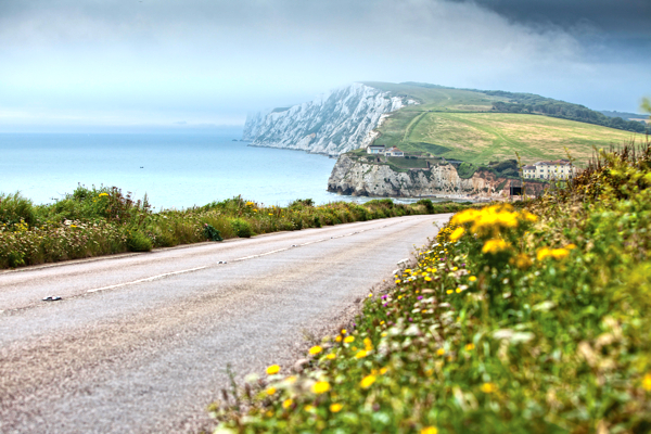
We would suggest driving it east to west simply because the views are so much better. As you leave behind the tourist traps of Ventnor and the east coast, the road winds through a glorious open – for the Isle of Wight – landscape, with open sea on the left hand-side.
There’s something about a view of the sea in the UK, and this is a particularly good run, as the road hugs the coast for almost all of the 11 miles.
Tight bends are relatively few, and sightlines are good, so you’ve got plenty of time to enjoy the view and the drive as you weave westward, with new views appearing every mile.
Yet, it is not until the last mile or two that the real gem of the drive appears. Just before Freshwater Bay, there’s a glorious couple of swooping ricochet bends, then the road straightens out and descends into one of the most picturesque road views in England.
Freshwater Bay appears, with its white cliffs and blue-green sea in all of its green-and-pleasant-land finery. You can almost hear the local Women’s Institute singing Jerusalem, that’s how typically English it is.
We grant you, 50mph is probably as fast as you’ll be going, but on this road that is ample. Great Drives are about the view as much as the tarmac, surely?
Besides the road being fun to drive and view, there is another reason we suggested this road. As recently as 2010, one landslide made a section of the road single file. Indeed, such is the chance of landslide that you’ll pass marker boards that are ready to illuminate the road’s closure as you drive it.
The council are currently debating what to do, with rumours saying that it could be closed in the worst affected erosion areas, and the remainder made into a cul-de-sac. Get on that ferry, and drive it soon!
More from Total 911

Frankfurt Motor Show preview

911 in Motorsport: British GT & Supercup report

N140, Pamplona, Spain


Comments (0)